ElevationToAreaAtDate

This function performs a lookup in the Reservoir object’s Elevation Area Table or based on a given elevation and datetime and evaluates to the corresponding surface area. This function must be used when the method is selected. Otherwise, the ElevationToArea function can be used and no DATETIME argument is required.

Description

Find the surface area corresponding to a reservoir’s elevation.

Type

NUMERIC

Arguments

Type

Meaning

1

OBJECT

reservoir object

2

NUMERIC

pool elevation

3

DATETIME

the datetime at which to do the conversion

Evaluation

On the specified reservoir object argument, if the method is selected, , the function will reference the table. The function will select the appropriate column to use based on the datetime argument. On timesteps that exactly match a modification date, the previous column is used. The relationship changes only at the end of that timestep and is taken into account when the reservoir dispatches. For this algorithm the previous column relationship is used.

Otherwise, the Elevation Area Table is used and the datetime is ignored.

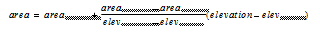
Then, the pool elevation argument is looked up in the Pool Elevation column to determine the Surface Area from the appropriate Surface Area column. If the exact elevation is not in the table, the lookup performs a linear interpolation between the two nearest bounding elevations and their corresponding surface areas.

Mathematical Expression


Comments

If the object is not a reservoir, or the reservoir does not have an Elevation Area Table or Elevation Area Table Time Varying , the function aborts the run with an error ( i. e. a method must be selected in the Evaporation and Precipitation Category).

 
ElevationToAreaAtDate(%"Lake Mead", 1210.03 "ft", @”t”)
 
634547087.2 [m2]